There were other cars parked at this point so we decided to stop driving and start hiking. We were up really early so we didn't see anyone on the road except people at their campsites just waking up. On the drive down we passed a lot of cars and bikes.
Pretty soon after we started hiking there was a giant snow drift along the road and Pickles went crazy. Something about snow makes dogs wild.
Shortly thereafter we got to the needle eye tunnel which is closed. There was a man in his dirt bike outfit looking through the tunnel that spooked Pickles (we had passed this guy earlier and Pickles was nothing but friendly). He barked a lot until we finally got close enough that he could smell the guy.
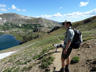
We climbed up over the tunnel and took the wagon road up over the hill towards the pass. When we arrived a the pass we realized there was an easier old rail road bed route that didn't gain any elevation from the tunnel (we took this on the way back). From the pass we decided to drop down to King Lake in Indian Peaks instead of heading up farther onto the High Lonesome trail. You can see King Lake below in the picture.
Pickles saw the snow field down the hill and started doing laps; he ran down the hill to the snow sprinted across it and then circled back up to us, seeing that we hadn't moved yet he did it again. It was a pretty far ways down and I think he ran at least 4 laps.
King Lake was beautiful. We stopped for lunch and Pickles went wading.
After King Lake we decided to continue on to Bob and Betty Lakes. These are at about the same elevation as King but you have to go down and back up to get to them. The wild flowers are amazing in this area.
 | |
| One the way we found the waterfall we had seen from the wagon road. |
 |
| Looking from the wagon road towards King Lake and Bob and Betty Lakes (see the waterfall). |
 |
| At the waterfall, the railroad bed is visible across the valley. |
 |
| On our way to Bob Lake looking back towards Rollins Pass, we arrived at the pass from the left. |
 |
| Bob Lake. |
When we got back to the pass, a couple of guys had set up a rail in the snowfield and were snowboarding. There was a pretty steep drop just to the right of them where the snowfield dropped over the edge, but I guess the snow was soft enough they could stop themselves easily.
We then crossed some awesome railroad trestles on our alternative route back. They were pretty exposed so we put Pickles on a leash.
We made it back to the car at 2pm, 6 hours after we started. Pickles was exhausted. And we still had to drive back down that awful bumpy. But we concluded that the awful drive was worth the amazing hike (though I'm not sure if we could do it again soon). Maybe the drive from the west side is better.


No comments:
Post a Comment